
- June 24, 2026
UPDATED: 11:15 a.m. Oct. 6:
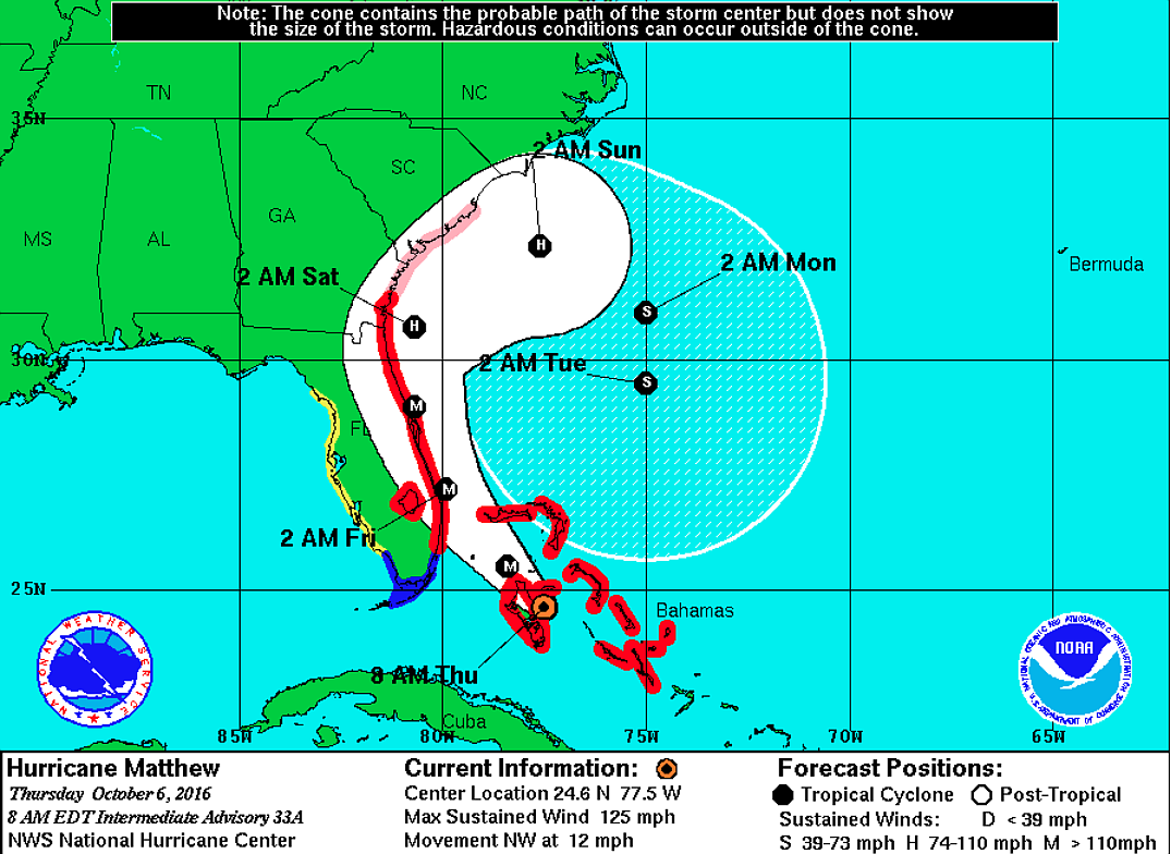
Hurricane Matthew remained on track the morning of Thursday, Oct. 6 to affect Flagler County, with the storm passing through the Bahamas at 12 mph with wind speeds of 125 mph.
The storm is expected to be a Category 4 storm at the time it approaches Flagler County. Emergency information is posted at flagleremergency.com, and the county has established a 24-hour information hotline about the storm for Flagler County residents and businesses at 386-586-5111.
EVACUATIONS AND BRIDGE CLOSINGS
Flagler County officials urged all residents to get to wherever they plan to be during the storm — whether evacuating or sheltering locally in homes or one of the county hurricane shelters— by 5 p.m. Thursday evening.
Mandatory evacuation orders have been issued for evacuation zones A, B and C, and officials also plan to issue an evacuation order for zone F, Flagler County Public Safety Emergency Manger Steve Garten said. (Check your evacuation zones HERE. The site takes several moments to load.) The mandatory evacuation means that emergency services personnel will not serve those areas.
Garten urged residents who are evacuating to head west, rather than north. “We are looking at severe traffic jams all the way up to North Carolina,” Garten said. Hurricane shelters will be set up in western Florida to accommodate those coming from the east.
Shelters have been set up at Bunnell Elementary for general population and people with pets; and at Rymfire Elementary for people with special needs. The county as of 10:30 a.m. Thursday was trying to arrange for transportation that would pick up residents at their homes who had registered for the special needs shelter. (For details on what to bring to a shelter, click HERE.)
Law enforcement officers will begin checking the ID cards of anyone heading east over the bridge to the barrier island at 4 p.m. Thursday, restricting passage to residents. The bridge will close at midnight. Emergency services personnel will not cross it once windspeed reach a sustained 45 mph.
AFTER THE STORM
Army Reserve troops will be setting up distribution points for water after the storm passes, Garten said.
FPL is staging vehicles at the county airport to be able to deploy quickly to restore power after the storm.
Flooding is expected in low-lying areas, and there may be storm surge; waves of 15-22 feet are expected.
Residents are asked not to try to remove debris themselves in the immediate aftermath of the storm.
“After this incident, there will be debris throughout the county,” Garten said. “Don’t … try to do it yourself, wait until we come to you.”


